
It has been a long time since I last updated any information on the tunnels of the Visoko valley, where the situation has changed significantly since 2006, when I wrote my first article. Given that the Osmanagic microcosm is now buzzing with the news of a “great discovery” (bs) inside the Ravne tunnel, now seems an appropriate time to review the facts, their interpretation by Mr. Osmanagic and his supporters, and the various hypotheses about the tunnel’s origins.
An underground labyrinth
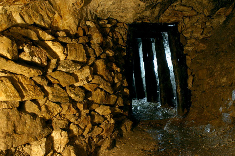
Let us begin with a description of the Ravne tunnel. This is a relatively complex underground system (a “labyrinth” according to Osmanagic, of course) with a gallery and a number of secondary branches, about 3 kilometres from the hill of Visocica, from which it is separated by several small valleys. It extends beneath a plateau, or flat ridge, that rises gradually from the north (Bosna valley) to the south, at an altitude of between 475 and 500 metres. The entrance to the tunnel itself is located on the western flank of the ridge, at a height of 470 metres:


Since the Osmanagic Foundation has never seen fit to publish an accurate description, it is impossible to give the exact altitude of the underground network, but, judging from all the photographs, it seems that we are looking at sub-horizontal galleries. In that case, the network cannot be situated at any great depth, between 15 and 20 metres below the surface at most.
We also lack detail about the full extent, and plan, of the network; yet again, the plans published by the Foundation are of limited use only:


In late 2010, the total length of the galleries cleared - about 350 metres (bs) in November 2010 - was extended by about 200 metres after the discovery of a section that, though unobstructed, was largely waterlogged:

Sandstone and conglomerate
The material through which the tunnel was dug is clearly of natural origin, despite the insistence of some pseudo-archeology enthusiasts that it is synthetic [1]. The geological map of Visoko identifies this terrain as Miocene conglomerates (Lasva series conglomerates); it is possible, however, given the lack of detail on the geological map, that these conglomerates are covered in places by an ancient alluvial terrace (at a height of 55 or 60 metres above the recent Bosnia alluvium at 420 metres) that is not shown on the map.
The geophysicist, Amer Smailbegovic, who visited the first part of the tunnel before the widening undertaken by the Foundation, also mentions these conglomerates in his unpublished geological report (see the first document on this page). He, too, classifies them along with the Lasva conglomerates that form the basis of the northern and eastern slopes of Visocica, describing them as a mixture of dolomite, quartz and slate, rounded off to a greater or lesser extent and unsorted, suspended in a friable, calcareous-sandy matrix [2] (page 8). On page 18, he also notes that the tunnel appears to have been established at the contact between the conglomerates of the upper series of Lasva, and the underlying older sandstone. The stratigraphic succession therefore seems to be the same as at Visocica: coarse sandstones overlain by conglomerates, but with local differences in sediment composition.


These are the same blocks of sandstone noted by Mr. Smailbegovic as being present in various parts of the tunnel ; according to him, their function is to reinforce some of the walls and divergent tunnels. Finally, let us note that, on the one hand, about thirty metres into the tunnel, he observes that there is a deterioration in the cohesion of the conglomerate, with an increasingly friable, non-cemented matrix; and, on the other hand, that the tunnel is very well ventilated. This he attributes to the presence of air ducts every 15 metres – although there is no trace of any such ducts to be seen on the various published photos of the tunnel, unless he considers the side openings as ventilation ducts.
Artefacts
To complete this description of the tunnel, we may note three particularly interesting points that have - very recently indeed - come to the forefront:
– the presence of drystone walls obstructing some galleries:


Sometimes these drystone walls are merely aligned with the walls of the tunnel:

– In the flooded part of the tunnel discovered in December 2010, the presence of a straight central channel:


(We may note that these photos do indeed appear to show the contact, mentioned above, between sandstone - here relatively fine - and conglomerate. Here again, the base of the tunnel seems to follow the exact line of the contact, with only the central drainage channel following a course through the lower layer).
– Finally, the last item of interest, which will perhaps shortly throw some light on the question, is the discovery by ground penetrating radar, on 23rd July, about 90 metres from the entrance of the tunnel, of the possible presence of a structure buried in the earth:

GPR images are very difficult to interpret, but, although it is far too early to offer any suggestions about the nature of this anomaly, it is very unlikely to be an object of natural origin.
A pseudoscience jamboree
At any rate, these three elements provide confirmation - if any were needed - of human intervention in the Ravne tunnel, something about which I was never in any doubt (see what I wrote in 2006). The second tunnel, known as the ‘KTK tunnel’, is situated in a very different geological context, apparently suffering regular flooding by the Bosna. Whilst not excluding the possibility that the KTK tunnel is largely of natural origin, therefore, the Ravne tunnel, except perhaps for a few small natural cavities of a sort that can be found even within a weakly calcareous conglomerate, is definitely an artificial manmade network. The question is: when was it dug, and for what purpose? And now the carnival of pseudo-scientific interpretations really gets underway ...
As far as Mr. Osmanagic and his friends, such as his supporters (or rivals?) in the SB Research Group, are concerned, there is no doubt that the Ravne tunnel is connected with the ‘pyramids’. This is a certainty beyond all question; even more than that, it is a prerequisite. Since 2005 (bs), Mr. Osmanagic has been claiming that there must be an ‘underground complex’. Given that there are underground tunnels beneath the pyramids of Giza and Teotihuacan, it necessarily follows that there must also be tunnels under the ‘pyramids’ of Bosnia. Therefore, any subterranean network discovered in the area must necessarily be part of such a ‘complex’. It is this assumption that forms the basis for the frequent utterances by Messrs. Osmanagic and Debertolis about the length of the Ravne tunnel being three kilometres [3] (i.e., the distance from the hill of Visocica), even though no more than 300 metres of tunnel had so far come to light.
The existence of claims for a ‘pyramid’-tunnel link, although never actually substantiated, means that, ever since 2006, the tunnel has regularly been cited as proof of the existence of the pyramids (see "proof" # 11, p. 17). Hence the desperate need to obtain the oldest date possible for the tunnel: the earlier that date, the stronger the ‘evidence’; the later the date, the weaker Osmanagic’s theory. There have been several attempts at dating samples from the tunnel, using either organic objects (or supposedly organic: see this discussion), or stalactites and stalagmites. These dates have yielded results with wide variations that strain credulity, from 2,000 or 3,000 years to more than 30,000. Nothing daunted, Osmanagic uses these dates, questionable pinpoints in time, as a basis for constructing a ‘customised’ chronology, bringing into play no fewer than four different civilizations:
– one over 32, 000 years old, responsible for constructing the ‘megaliths’. The ‘megaliths’ would have been located above underground streams, although at a time before the tunnels were in place (see below): so, presumably, out in the open.
– a second, dating to between 32,000 YA and 5,000 YA, that built the pyramids and excavated, or constructed, the tunnels. The assumption is therefore either that the conglomerate through which the tunnel was dug was deposited at some stage later than 30,000 years ago (according to the theory of Semir Osmanagic’s father, Muris Osmanagic, see here; and of Semir Osmanagic himself, who believes that this second civilization is certainly “much less than 32.000 years, because time was needed for conglomerate to form from the floods and conglomerate sedimentation”); or, the theory favoured by Professor Debertolis (see this article (It.)) [4]: that the tunnel was built from scratch, using an artificial conglomerate, and then covered with 20 metres of sediment.
– a third civilization, dated to a time before 1000 BC, who used huge amounts of material to close the tunnel off, and also ‘cleaned’ it, which would explain the complete absence of artifacts.
– and a last civilization, the only one that Mr. Osmanagic slots into traditional chronology, as he concedes that there could have been an occupation of the tunnel for a time during the Neolithic somewhere between 3000 and 4600 BP.
Debatable datations
This chronology, based on three civilizations hitherto completely unknown to anyone studying Bosnian prehistory (and of which there are no traces other than the tunnel, the tunnel ‘megaliths’ and the ‘pyramids’), is based on a very small number of dating tests (six in all, according this text (bs)), of which at least some are highly questionable. I have already discussed here the case of the ‘piece of wood’ extracted from the tunnel, which might very well be no more than a Miocene fossilized wood, therefore yielding an anomalous dating result. The dating tests carried out on ‘stalactites’ and ‘stalagmites’ are just as inconclusive. In itself, of course, the idea of dating speleothems found in a cavity is not stupid: far from it. For example, testing the dates of stalactites found in this part of the tunnel, where we can be sure of their development in a pre-existing cavity, could not fail to be of interest:

However, the objects that the Foundation sent for dating had no resemblance at all to stalactites and stalagmites! The sample dated at 5,080 years, for instance, described as having come from a stalagmite, is shown in this document to be something else altogether!


Instead of a stalagmite that has developed exposed to the air inside a cavity, it appears to be a calcite vein that has developed in rock fractured by water circulating within the mass of the conglomerate. Such calcite veins can develop within a rock mass without necessarily occupying an empty space. Water rich in carbonates circulates through the rock, infiltrating microscopic cracks where calcite crystals will slowly grow:

This, therefore, is probably, a case where first, the layer of calcite has formed within the conglomerate, and, subsequently, a piece of conglomerate has become detached following a rupture, rather than vice versa. The material dated would therefore give a result that would be the age of the calcite deposit in the crack, rather than the date when the tunnel was dug (see also this interesting discussion (it) with Italian geologists on the subject). Generally, what observers find striking is the low number and poor development of speleothems in these galleries; even with a matrix weak in carbonate, which would therefore mean a very slow development of stalactites and stalagmites, one would expect a tunnel several thousands or tens of thousands years old to contain stalactites somewhat longer than 5 centimetres, as I have already noted here.
We are therefore left with two isolated dates (3000 and 4600 years). The Foundation remains rather vague about the context of these samples; for example, in the case of sample ‘Visoko 1’ mentioned in this document (bs), we learn that it was just taken “close to megalith K2”, and that it is “a red material that looks like scorched earth”. The sample sent to Uppsala is described here (bs) as coming from “the remains of a hearth at the foot of the wall of the tunnel”, but the photos do not show anything resembling a hearth:

In short, not exactly abundant evidence on which to construct a chronology as specific as the one devised by Mr. Osmanagic (and used by Mr. Debertolis) and which to use as the basis for positing the existence of three unknown civilizations ...
Thaumaturgical Chernobyl
Now to the question of the purpose and use of the tunnels, a subject on which the pseudo-archaeologists’ imaginations break joyously free of all bounds. Each and every hypothesis is successively, or sometimes simultaneously, presented. Thus, the Ravne tunnel could be a place of worship, of sacrifice, of healing, or of energy production; or a tomb, a prison, or a potential Chernobyl ... There is no evidence yet, of course, to support any of these suggestions, and neither Osmanagic nor Debertolis seems able to choose between them – although this doesn’t prevent these theories being thrust in our faces as facts rather than hypotheses. We learn that the tunnel supposedly forms part of “a labyrinth tens of kilometers in length”, linking all the ‘pyramids’ together; that the tunnel had a defensive function, with the ability to repel invaders by creating unlimited numbers of artificial whirlwinds (bs); that it was “a place for regeneration and revitalization” capable of transforming ‘negative energy’ (sic) into ‘positive energy’ (re-sic); that it was used as a quarry for the extraction of materials used to build the ‘pyramid’ of Visocica; that it was used for sacred rituals; and that within it lies “one of the oldest ceremonial altars on the Planet”... The members of the Italian ‘scientific team’ are very much in the forefront on this question, managing to transform the tunnel not only into a piece of ‘bio-architecture’ with thaumaturgic effects, capable of treating arthritic conditions, but also into a veritable ‘Pandora’s Box’ containing some unspecified danger purposely sealed off by the blocked tunnel, perhaps “something like Chernobyl”, also guarded by mysterious misty entities capable of moving independently of air currents.
The discovery of a structure buried beneath the tunnel floor (bs) has received little by way of comment on the website of the Foundation, which remains remarkably tight-lipped (bs), refusing to suggest any interpretation at all before the results of the investigations are known [5]. But the discovery has given new life to the imaginations of the SBRG members, particularly to Professor Debertolis. On his website (it) appears, with a bravura flourish, the following claim: the anomaly detected by ground penetrating radar is a “very ancient grave” - and this is “confirmed” (“L’anomalia al georadar all’interno dei tunnel si è dimostrata essere una tomba molto antica con due camere”) – containing “two very important people”, perhaps a king and a queen (“È chiaro che si tratta di due persone importanti. Un re e la sua regina ?”). It was most probably with a view to protecting this tomb that the tunnel was completely blocked off with soil for 350 metres (“Soprattutto appariva inspiegabile il fatto che fossero stati chiusi per una lunghezza di circa 350 metri con terra fino al soffitto”). The story as told by Professor Debertolis also involves grave robbers, and even human sacrifice, involving some hapless victim who, in his last agony, buried alive with the king and queen (“Se qualcuno è stato chiuso vivo dentro i tunnel la motivazione poteva essere solo per una ragione veramente importante. [...] D’altra parte conosciamo altri episodi storici di questa terribile abitudine di tumulare persone vive accanto alle salme di persone importanti anche in altre civiltà.”), desperately clawed at the walls of the tunnel with his bare hands (“L’idea di cercare una tomba importante ci è venuta in mente presi dall’emozione dei segni di graffi che abbiamo trovato sulle pareti nella sezione dei tunnel oltre la parte sigillata dalla terra”).

A not-so-hermetic sealing
Gripping stuff ... although with not much in the shape of solid foundation to it; and we can only note the ease with which Professor Debertolis gets carried away on his flight of fancy. This is not a criticism: imagination, rather than Bachelard’s “epistemological obstacle”, is a quality often found in scientists. Nevertheless, it still remains necessary to confront the hypothesis offered up by the imagination with the observed facts. One should also check that these facts do not have some simpler explanation, requiring rather less by way of unsupported proposition and supplementary hypothesis (principle of parsimony, or Ockham’s razor).
In the case of the Ravne tunnel, Ockham’s razor is cheerfully binned by both Messrs. Debertolis and Osmanagic. All their assumptions about the tunnel require, on the one hand, acknowledging the existence of two or three civilizations hitherto completely unknown to experts in Balkan prehistory; and, on the other hand, the existence of a wide range of phenomena, some non-measurable by modern science (the ‘negative energy’ of underground streams, Hartmann grid ...), or other phenomena that have not withstood rigorous analysis (‘artificial concrete’ from the ‘pyramids’, or ‘synthetic stone’ from the ‘megaliths’ in the tunnel ...). Moreover, it seems to me that certain facts are heavily exaggerated or distorted if circumstances require.
I will take one example, that of the alleged ‘sealing’ of the tunnel, effected with the purpose of protecting its secrets. While there is no doubt that the side galleries have been blocked with earth and boulders, and walled by stacks of dry stone, it does not appear that the main tunnel has ever been intentionally blocked off (although, of course, this is the sort of thing that might have been expected in the event of there being a wish to protect the supposed "royal tomb" located 90 meters from the entrance). This tunnel was known to the local inhabitants – especially children - before Osmanagic came on the scene. In April 2006, according to Amer Smailbegovic, before the Foundation had carried out any work, some 342 metres of it were just about accessible. Until the end of 2010, the work effected by the Foundation consisted principally of widening the gallery, securing it, and opening up of some of the blocked side galleries. A video dated 15th April 2006 shows the state of the tunnel, which on that date was generally practicable (the Foundation did not begun work there until the winter of 2006-2007 (bs)). Charcoal graffiti can clearly be seen on the walls, for example, in about the second minute.

At least as far as the main gallery is concerned, we are probably not looking at a gallery that was intentionally closed off by a people of mysterious origin. Instead, we are simply looking at an abandoned gallery, with crumbling walls that have gradually collapsed, making access ever more difficult [6]. The only galleries to be intentionally walled off were some secondary ones (see also this video dated 13th March 2007, made during the widening of the very first part of the tunnel).

Pipe dream
Of more interest is the fact that the tunnel seems to have been in use in one way or another, until the second half of the twentieth century. Indeed, at a point 30 cm below the ground, above the structure detected by GPR, a fibre cement drainage pipe was found:


This pipe was first mentioned on the David Icke forum by the ‘geologist’ Richard Hoyle. As far as Hoyle is concerned, the pipe was placed there in the 1960s. Despite acknowledging a ‘minor inconsistency’ with the ‘official’ version, according to which the tunnel was completely blocked until its ‘discovery’ by the Foundation, he did not seem unduly bothered by it – in contrast to some other contributors to the same forum, and also contributors to the Italian forums (it) frequented by members of the SBRG. As some of these forum contributors immediately realized, this evidence of 20th century use of the tunnel raised a lot of questions. Whatever its purpose in ‘antiquity’, it is difficult to relate the tunnel’s contemporary use to any of the theories mentioned above. People using it during the 20th century probably had good reason to do so, and efforts should be made to find that reason.
The members of the SBRG have tried to play down the story of the pipe. Debertolis says that it was made “recently”, without specifying when. Andrea Venturini, the group photographer, confirms (it) that the pipe was put in place by Foundation employees “three years ago at most”. Whilst this is not impossible, the April 2006 video mentioned above appears to show an exactly similar piece of pipe near one of the ‘megaliths’ at least twice (at about points 4’43" and again at 5’33"):


So: could the pipe have been in place no earlier than three years ago? Or was it put there long before, perhaps several decades earlier? If I were the Foundation or the SBRG, I would make trying to resolve this matter a priority. If it turns out that, at some time during the 20th century, a system of drainage pipes was actually laid some dozens, or hundreds, of metres inside the tunnel, I would endeavour to find out why ...
Military
One theory about the history of the tunnel that I have sometimes seen suggested on certain forums, for example here, is that it was used by the Yugoslav army, the JNA, perhaps to store ammunition. The same hypothesis has also sometimes been suggested for the other tunnel, the one known as ‘KTK’, which at one time served as storage, if not for the army, at least for the organization of that name. As far as the Ravne tunnel is concerned, the hypothesis does not seem to stand up too well. The tunnel could possibly have served as a temporary cache, such as for members of the resistance during World War II, or during the 1990s conflict, but no modern army would store ammunition in such narrow tunnels with such crumbling walls just for the fun of it – and all without leaving any trace of installation. None of the other theories sometimes suggested (Roman undermining tunnel, mediaeval tunnel linking up with the fortress of Visoki, water collection ...), meanwhile, seems able to explain both the relatively recent use of the tunnel, and also fit the various characteristics described at the beginning of this article.
Waste rocks, stone-walling and back-filling
There is, however, one theory which, although unfortunately lacking the exotic character of those developed by Messrs. Osmanagic and Debertolis, could very well explain most of the features of this tunnel, and which I shall briefly discuss here. Let me be absolutely clear: I’m not trying to do ‘armchair archaeology’! All I’m trying to achieve is simply to show that the theories put forward by the pseudo-archaeological community are not written in stone, and that there is a possible explanation for the Ravne tunnel that is less far-fetched, and perhaps more consistent with both the historical and archaeological context, and also the geological context, even if it is possible that the reality still might turn out to be something else altogether.
The first point is the undeniable resemblance of all the characteristics of the Ravne tunnel with those of an ancient mine. Indeed, it is not uncommon to find in ancient, medieval, or even 18th or 19th century mines, features similar to those observed in the Ravne tunnel. The drystone walls along the galleries, for example, represent a technique often used to dispose of waste rock without having to transport it outside the mine. In areas where the sediments were poorly consolidated, it was also a way of shoring up the walls. There are many examples in mines of the modern era:


Compare this with the Ravne tunnel:

It is also common to find some galleries blocked by waste stones, either because the galleries in question were exhausted, or because they were trial galleries that proved unproductive. Infilling these galleries has the advantage of getting rid of waste materials, and at the same time reducing the risk of collapse:

The Greeks were already practising such techniques in the silver mines of Laurium (fr), although, in that particular case, it seems to have been with a view to saving air, difficult to renew at these depths. More recently, in the modern era, this technique has been systematically used on a large scale in underground quarries (for example, in Paris (fr) until the 19th century), and was known as “stone-walling and back-filling” (“hague et bourrage”). “Back-fill” (“bourrage”) consisted of waste rocks (or low-grade stone not good enough for quarrying), while “stone-walling” (“hague”) referred to dry-stone walls.
Another feature of the Ravne tunnel is the presence of a drainage system, consisting, as we have seen, of either a pipe dating probably from the second half of the 20th century or – in the case of the best preserved part, lying deeper - of a central gutter:

channel that the Foundation is in the process of reproducing downstream from the structure discovered by GPR!

This type of drain, whether central, or whether - as is more often the case - to one side of the gallery, is common in old mines:


Sometimes, for ease of movement, the central channel was covered by wooden planking, as was the case in the medieval mine of Rammelsberg:

(See also this page (fr) on mining techniques, in particular Figure 16, which shows an overdeepened floor, topped by a boardwalk).
Primary deposits, secondary deposits
If the Ravne tunnel was really an ancient mine, is it possible to determine what was being mined there? The location of the tunnel in the Lasva series sedimentary layers excludes intrusive deposits (see here for the geological context, and there for the different types of metal ore deposits). Coal deposits, of the sort known in the older layers (Lower Miocene) of the Zenica-Sarajevo basin, seem to me unlikely here: the Lasva series contains many fragments of coal and lignite, but not the sort of deposits that would warrant opening up a mine. The Ravne conglomerates, detrital rocks formed from ancient alluvial deposits carried by rivers during the Early Miocene into the Zenica-Sarajevo basin, would predominantly contain alluvial deposits; and amongst ore deposits of this type, my preferred hypothesis would be that of a placer gold deposit, or ‘paleo-placer’ [7]. A few details:
There are several different sorts of gold deposit. The first is known as a ‘primary’ deposit. This particular form of deposit, associated with magma intrusions, is generally found in veins formed by deep hydrothermal circulation, most often associated with quartz.
Gold is also found in so-called ‘secondary’ deposits. Following the surface erosion of primary deposits, the gold, in the form of detritus, is gathered up, together with other material produced by erosion (sand, gravel, pebbles), and transported by watercourses for greater or lesser distances. When the current loses momentum, the material is then deposited in a ‘placer’ on the bed of the watercourse, or in a delta.
There are even ‘tertiary’ deposits, where an ancient placer, having become consolidated, is subjected to erosion by a modern watercourse that gathers up the flakes or grains of gold, resulting in a new placer on the waterbed that can then be worked.

Source
The most important primary gold deposits in Bosnia are located in the Vranica range (in the ‘Mid-Bosnian Schist Mountains’), to the west of Visoko, around Fojnica and Bakovici. They consist of gold bearing quartz and pyrite veins located at the contact between intrusive rhyolite (quartz porphyry), marked X on the map below (in red), and metamorphic sedimentary rocks (shales and slates) of the Silurian and Devonian, shown on the map as SD and D (dark grey and light grey):

Between the two World Wars, the principal gold mine in Bosnia was in this region, in Bakovici, but mining of primary deposits in this area goes back a lot further. A document dating to 1365 mentions gold- and silver-mining in Fojnica (bs). In “Les mines d’or et d’argent en Serbie et Bosnie” (fr) (“Gold and silver mines in Serbia and Bosnia”, 1960), the historian Desanka Kovacevic analyses the veritable ‘gold rush’ and ‘silver rush’ experienced in the Fojnica region during the fourteenth and fifteenth centuries. Even earlier still, in the Roman era, if the map published by Alfred Michael Hirt in "Imperial mines and quarries in the Roman world" is anything to go by, there was a heavy concentration of gold-, silver-, iron- and copper-mines in the valley of the Fojnicka (Kresevo, Ostruznica, Busovaca ...) It is possible that there was mining for gold in the Vranica range even before the Roman era, as prehistorians have shown that there was early development of copper and gold metallurgy in central Bosnia (see, for example, page 23 et seq. of this article (bs), where Ms. Kujundzic-Vejzagic examines the transition from the Neolithic and Chalcolithic (‘Eneolithic’) in sites like Butmir and Okoliste - see in particular page 32).
Gold-panners and paleo-placers
When the primary deposits of the Vranica range reach surface level, they are of course subject to erosion. As the left bank tributaries of the river Bosna come down from the mountains, gold is picked up and carried by the watercourses such as the Lasva, or the Fojnicka which join up with the Bosna at Visoko. Panning for gold - washing river sediments to find these gold particles - is attested in antiquity on the Lasva and Fojnicka: see "Antiquarian Researches in Illyricum" by Arthur John Evans, who, on page 125, mentions that, in the Roman province of Dalmatia, in addition to slaves working in the imperial mines, there were independent gold washers as well, auri leguli. According to German travel writers, gold washers were also to be found during the nineteenth century: see, for example, "Geologische Führer durch Bosnien und die Hercegovina" (de) by Friedrich Katzer (page 60). The official Fojnica town website also mentions gold-bearing sands (bs) in the river Zeljeznica (a tributary of the Fojnicka, not to be confused with another Zeljeznica, that flows into the Bosna near Sarajevo) and the river Dragaca, and gold washing is even mentioned as a tourist leisure activity!
Of course, this erosion by watercourses in the modern era must have taken place in the past as well [8]. In the Miocene, at the time of the formation of the Zenica-Sarajevo lake basin, the intrusive Vranica massif was already uplifted, and paleo-rivers - the ancestors of the Lasva and Fojnicka of the present day – carried debris sheared from the mountain, including quartz and pyrite gold, down to the lake. There was, therefore, nothing to prevent a local concentration of gold within the sediments deposited in the lake basin, and thus the formation of ancient placers created by the Miocene watercourse system. Such types of ‘paleo-placers’ occur frequently and are well known; some have provided, or still are providing, very high tonnages of gold. Examples are:
– The Witwatersrand in South Africa, which has provided nearly 40% of the total amount of gold mined worldwide, consists of a very ancient conglomerate deposited in a sedimentary basin over 2.5 billion years ago. I cite this only by way of an indication, the geological history of the Witwatersrand being very different from the examples below.
– The El Boludo placer, in the state of Sonora in Mexico, consists of tertiary age sediments transported to a lake basin from surrounding mountains with rhyolitic intrusions. In it are found alternating layers of conglomerate, micro-conglomerate and sandstone, most of the gold being concentrated at the base of layers of conglomerate. The deposit is interpreted as a series of alluvial fans in a lacustrine environment at the mouths of watercourses in the ancient lake.
– The gold deposit of Las Médulas, worked on a massive scale by the Romans in Spain, is also formed of Miocene conglomerates:

– Another interesting example is the Napf (fr), in Switzerland. Streams in this region contain abundant gold, whose source is most likely a secondary deposit within the conglomeratic massif (Miocene molasse) of the Napf. The paleo-placer, or paleo-placers, of the Napf have not yet been identified, but some ‘aficionados’ are making active efforts to find these placers by digging tunnels through the conglomerate ...
– Examples of nineteenth century mining in paleo-placer conglomerates in the county of Okanagan, British Columbia:


This type of gold deposit, although not very common, can nevertheless be found in Bosnia. Ms. Kujundzic-Vejzagic here describes (bs) a recent discovery of auriferous conglomerates in the area of Praca and Renovica (to the east of Sarajevo), and there are allusions to this sort of deposit in ancient geological works such as "Einiges Uber Das Goldvorkommen In Bosnien" (de) by Anton Rucker, pages 64 and 97, which mentions the area surrounding Bistrica and Fojnica. A little further over, in Serbia, tertiary gold-bearing sediment strata are to be found in the valley of Timok, as described by Dushan Iovanovitch in "Les richesses minérales de la Serbie" (fr), page 30. Moreover, in "La Bosnie populaire" (fr) (page 264), the French journalist Albert Bordeaux, who travelled through Bosnia in 1904, describes how he met a prospector, a larger than life character, who claimed to have access to "underground placers like the ones in California", a description that could not apply to watercourse placers of the present day, and could therefore refer only to ancient placers in a consolidated sediment.
Conglomerates and paleo-Fojnicka
Is it possible that the Ravne conglomerate could have contained a paleo-placer of this type? In the current situation, it is, of course, impossible to come to any conclusion, but there are several pieces of compatible evidence that suggest that this hypothesis should at least be considered before resorting to such explanations as "royal tombs", "thaumaturgic bio-architecture" and other scenarios liberally spiced with the mysterious and the quasi-supernatural. Amongst such evidence we find:
– in the Ravne tunnel conglomerate, there are elements, particularly quartz and metamorphised schists, that could well have had their origin, via an ancestor of the present day Fojnicka, in Primary outcrops of Vranica range.
– The fact that the tunnel seems to systematically follow the contact between underlying sandstone and conglomerates is particularly interesting. In a period of low erosion and unhurried sedimentation, with sluggish watercourses (which results in sandstones, clays, and marls), there would be little chance for gold, which is extremely heavy, to be transported over long distances. Only phases of very active erosion (more likely to result in coarse conglomerates), and flash floods, would be capable of transporting the ore as far as the lake basin. Because of its density, gold will tend to settle at the bottom of the bed, that is to say, in contact with the substrate – which, here, is the sandy bed already consolidated during the previous sedimentary cycle. It is therefore at the bottom of a conglomerate sequence, just above the underlying layer, where gold would be more likely to be found:
– The very configuration of the tunnel is completely compatible with the idea of a paleo-placer. Gold would not be uniformly dispersed through the layer of conglomerate, but instead would be concentrated in pockets on the bed of an old watercourse, or in multiple channels of an alluvial fan. The configuration of the tunnel could thus reveal attempts to track and identify areas where minerals are highly concentrated, with multiple examples of test-galleries abandoned - and infilled - when they prove unproductive.
.
Desperately seeking artifacts
Given these circumstances, how old might the tunnel be? In the absence of clearly dated artifacts, this is hard to say. The fragility of the walls would make me plump for workings of recent date - during the nineteenth century, perhaps continuing into the twentieth century - which would explain the presence of the fibre cement drainage-pipe (a form of cement not produced before the early twentieth century). But it is also possible that such a deposit could have been worked at several different times, with medieval or ancient workings being rediscovered and re-used in the nineteenth or twentieth centuries. The dating of old mine workings is often problematic, later resumptions of ore-extraction often having the effect of erasing any earlier traces, and removing any artifacts that might otherwise have served for dating purposes. There are examples of such difficulties in the case of some of the Roman mines in Rosia Montana studied by a team led by Beatrice Cauuet (fr). In this document, for example, on page 88, is a reference to a site that it has been impossible to date, because modern extraction work has removed all traces of ancient working, including charcoal that could have provided dating evidence.
The ‘total absence of artifacts’ in the Ravne tunnel, attributed by Osmanagic to its ‘cleaning’ by one of his mysterious civilizations, should be put into perspective. On the one hand, one can hardly be surprised by the disappearance of all artifacts from areas of an abandoned gallery that are still accessible. On the other hand, there are still some artifacts remaining in the tunnel: a drainage pipe, a gutter, drystone walls, tool marks on certain walls (Debertolis’ ‘agonized clawings’), a niche that might have served to hold a lamp:

These are not, perhaps, quite the artifacts that Osmanagic had been hoping for, but there is nothing about them that is inconsistent with the hypothesis of a small-scale mine. Moreover, there is the question of whether all the artifacts that were found were published. For example, a 2010 volunteer mentions in his Facebook profile ‘pottery’ found in the tunnel, near the underground ‘lake’. I have, however, found no mention of pottery associated with the tunnel either on the Foundation website, or in the SBRG documentation. There is also the possibility of small artifacts (nails, small coins ...) remaining unnoticed by the excavators. Indeed, as shown in the first minutes of this video, it appears that sediment extracted from the tunnel is not sieved.
Finally, the scarcity, or absence, of artifacts in an old mine is hardly a unique phenomenon. Back at Rosia Montana, galleries attributed, thanks to their shape, to the Roman era, contained no artefacts at all (page 87): no drainage or ventilation, no lamps or niches for lamps, even in the parts at the greatest depth. It is often outside, rather than inside, mines, in the dumps (or tailings), that artifacts of interest are to be found. If Ravne really is an ancient mine, there should be found, fairly close at hand (preferably in a place with a good supply of water) the remains of washing operations, which could presumably have been carried out by rocker, long tom or sluice.

Finally, on the subject of this particular hypothesis, we may note that Osmanagic, relying on the opinions of ‘experts’, categorically rejects - and we can understand why - the theory of an ancient mine. The ‘experts’ in question are not experts in mining archeology, but coal miners from Zenica, and Dr. Sci. Enver Hasic, an expert in mine safety (bs). Hasic provides two arguments opposing the theory that this was a mine. "No mineral deposits have been found" – but was a proper search conducted? Unlike coal, it is not usually possible to see deposits of gold with the naked eye... And: "all mines in Bosnia-Herzegovina have been documented". However, I very much doubt if all ancient mines really have been documented ... especially in the case of a working that might have been a rather artisanal mine, perhaps led by a small group of villagers working independently. A survey of older residents of the sector might turn up something, if the mine in question was in use forty or fifty years ago - and if oral tradition has not already been displaced by the ‘Osmanagician’ version of local history. The tedious job of extracting information from the local archives, if they still exist, might also provide some information on how the Ravne tunnel was used. It goes without saying that, although, before proceeding to excavate, a team of serious archaeologists would have carried out work of this sort in order to amass as much information as possible about the context, there is small chance of the Foundation undertaking any such exercise...
Where I eat my (Italian straw) hat
Whatever happens, the search for the ‘structure’ recently revealed by GPR will perhaps help to throw at least a little more light on the subject of the Ravne tunnel. If it reveals the tomb of a king and a queen dating to several thousand years ago, I will have to eat my hat ... If it turns out to be a cache of resistance weapons dating to the 1940s, we will at least have cleared up the question of recent use of the tunnel, although without obtaining any information about its origin. Is there a possibility that it might be a mining structure, such as a pit with the remains of timbers [9]? Time will tell, probably very soon ...